These are three maps of Bastrop County, Texas, head-right surveys which are presented in digital format:
- Von Rosenberg Map of Bastrop, 1881
- F.M. Douglas' 1899 Survey of Bastrop County
- County sponsored Map of Bastrop Count of 1929
The maps are in multiple sections and Google Earth overlays (in .kmz format) for each map may be downloaded at the links provided in the accompanying descriptions.
Please note: Most of the images are very large. The .kmz files which will open Google Earth are small. However, when a map section is selected in Google Earth, it will download each large image and overlay it in its proper location. If this presents a problem let me know and I may be able to supply lower resolution images for you to download.
Von Rosenberg Map of Bastrop, 1881
Von Rosenberg's map is quite beautiful, and shows headright boundaries, creeks and the river; all of which are named. Headrights of the Austin Colony are outlined in blue.
I purchased a full sized print of this historic map from the
Texas General Land Office and then scanned it, using software to knit it together into a single unit and then break it back down into nine pieces in a 3 by 3 grid for use as a .kmz file (a Google Earth overlay
which you may download here). As follows:
Top row, left to right (northwest to northeast):
 |
| northwest |
 |
| north central |
 |
| northeast |
Middle row, left to right (middle west to middle east):
 |
| middle western |
 |
| middle central |
 |
| middle eastern |
Bottom row, left to right (Bottom west to bottom east):
 |
| southwestern |
 |
| south central |
 |
| south eastern |
F.M. Douglas' 1899 Survey of Bastrop County
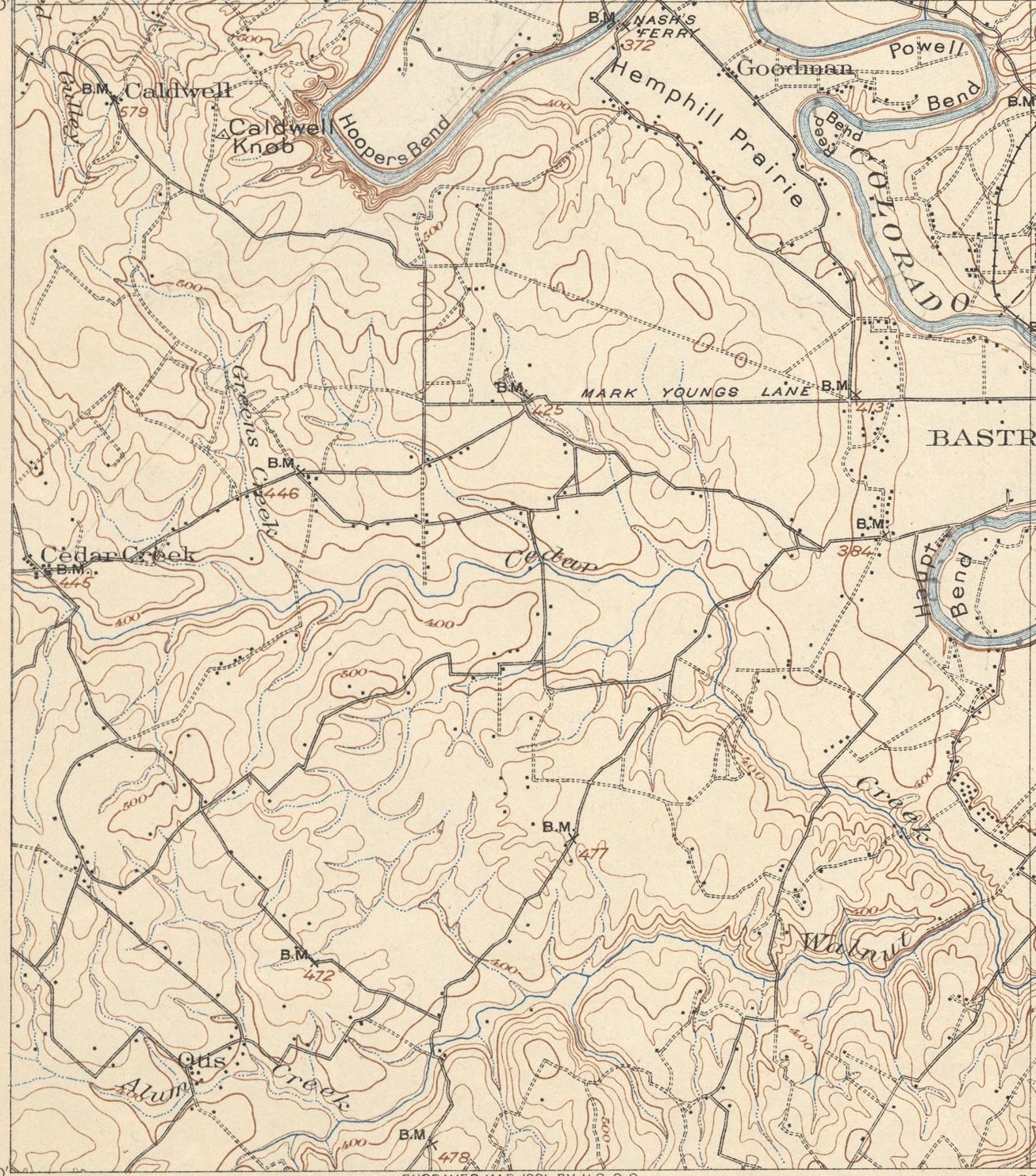
The 1899 Survey Map of Bastrop County, Texas, shows headrights, creeks, the river, elevation, and then existing roads and railways, but does not include the southern-most portion of Bastrop County. Additionally, like a fire map, structures are indicated. Due to the rectangular section format, it includes detailed coverage of parts of Travis, Williamson and Lee Counties. Gotier Trace (a.k.a., Gocher Trace, and other variants, which was also then referred to locally as "the stage road") and the San Antonio Road are of particular note.
It is, like the map above, laid out in a 3 by 3 grid, and available as a .kmz (Google Earth overlay,
which you may download here) as follows:
Top Row:
 |
| Bastrop 1A |
 |
| Bastrop 1B |
 |
| Bastrop 1C |
Middle Row:
 |
| Bastrop 2A |
 |
| Bastrop 2B |
 |
| Bastrop 2C |
Lower Row:
 |
| Bastrop 3A |
 |
| Bastrop 3B |
 |
| Bastrop 3C |
County sponsored Map of Bastrop Count of 1929
An inverse blueprint map commissioned by the county dated 1929, indicating headrights, roads, railways, streams and the river. The survey includes greater detail in names, sub-divisions, and acreage than the other maps. The original image was taken from a composite of skewed camera angles, but has been digitally flattened for a more uniform presentation. The sections are in 5 unequal rows totaling 20 images. This too, is available as a .kmz (Google Earth overlay,
which you may download here).
First row in four sections:
 |
| A1 |
 |
| A2 |
 |
| A3 |
 |
| A4 |
Second row in five sections:
 |
| B1 |
 |
| B2 |
 |
| B3 |
 |
| B4 |
 |
| B5 |
Third row in five sections:
 |
| C1 |
 |
| C2 |
 |
| C3 |
 |
| C4 |
 |
| C5 |
Fourth row in five sections:
 |
| D1 |
 |
| D2 |
 |
| D3 |
 |
| D4 |
 |
| D5 |
Fifth row in a single section:
 |
| E1 |